 Your post is being uploaded. Please don't close or refresh the page.


Federal emergency authorities removed dozens of structures from a Texas summer camp’s official flood hazard map in the years before a catastrophic flash flood tore through the facility, killing children and staff. The exemptions enabled new construction and reduced oversight in a high-risk zone long known for deadly flooding.
Camp Mystic, a nearly century-old private girls’ camp located along the Guadalupe River in Kerr County, was originally placed within a Special Flood Hazard Area in FEMA’s 2011 National Flood Insurance Program map. That designation would have subjected the camp to federal requirements for flood insurance and tighter restrictions on new buildings and renovations.
But FEMA granted two rounds of appeals submitted by the camp, first in 2013 and again in 2019 and 2020, which together removed at least 30 structures from the flood map, The Associated Press reported. The first appeal applied to 15 buildings at the original Camp Mystic Guadalupe site, while the second covered another 15 buildings at a newly developed area called Camp Mystic Cypress Lake, which began operating in 2020.

Subscribe to get daily/weekly email with the top stories (plus special offers!) from The Christian Post. Be the first to know.
The exemptions remained in place as the camp expanded and rebuilt.
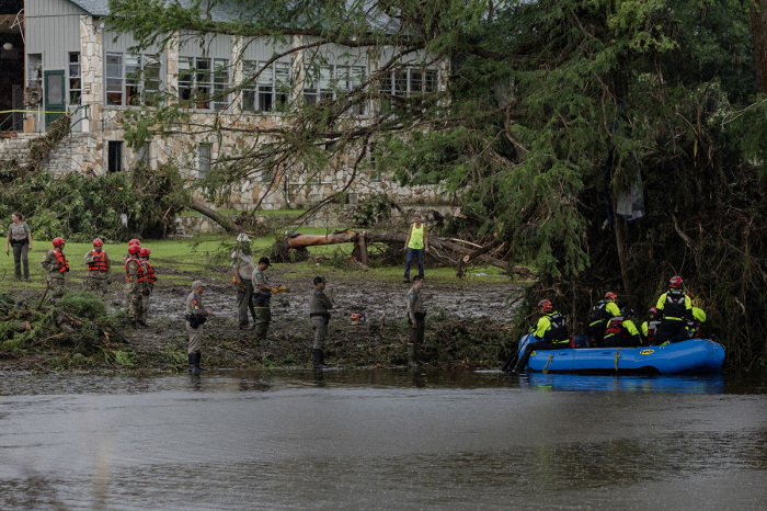
On July 4, before dawn, a torrent of water from the Guadalupe River inundated large parts of both sites, killing 27 at the site, including campers, counselors and the camp’s longtime owner, Dick Eastland. The water rose quickly and with force, destroying cabins known as “the flats,” which sat closest to the river, while structures at the Cypress Lake location also sustained damage.
Emergency response was hampered by the lack of a warning system in the county, and the flood’s intensity exceeded what FEMA’s 100-year flood map had anticipated. Experts said the event was far more severe than the so-called 1-percent annual chance flood used as a baseline in FEMA’s hazard zones.
For Syracuse University professor Sarah Pralle, who has studied FEMA’s floodplain management practices, the decision to exempt so many buildings at a youth camp from regulation was deeply concerning.
Such appeals are often used by property owners to avoid costly insurance premiums or construction limits. “It’s a mystery to me why they weren’t taking proactive steps to move structures away from the risk, let alone challenging what seems like a very reasonable map,” she said, as cited by the newswire.
FEMA has not publicly explained the rationale for the exemptions. Under its standard process, the agency accepts map amendments when property owners submit engineering data showing that buildings are outside the floodplain. Once removed, those structures are no longer bound by mandatory insurance requirements or certain development restrictions.
In a brief statement issued days after the flood, Camp Mystic described the event as an “unimaginable tragedy” and said it had restored power to allow communication with families and supporters.
Even before the exemptions, the site had long faced flood risk.
First Street, a data science organization that models climate and flood risk, found that 12 structures at Camp Mystic Guadalupe were fully within FEMA’s 100-year floodplain, while several others were partially located inside it. The firm’s model, which accounts for rainfall intensity and runoff, indicates that nearly the entire original camp lies within the zone vulnerable to a 1-percent annual chance flood.
Jeremy Porter, head of climate implications at First Street, said FEMA’s flood maps often underestimate risk because they rely on historic river data and exclude smaller waterways such as creeks and intermittent streams.
The buildings at the Cypress Lake property, although farther from the Guadalupe River’s south fork, are located near Cypress Creek. FEMA’s official floodplain does not classify the creek as a flood risk. However, First Street’s model, which incorporates surface water runoff and topographical data, shows that most of the Cypress Lake site is also susceptible to flooding during a 100-year event.
Campers who survived the flood said cabins at the Cypress Lake expansion were damaged by water and debris, though they did not suffer the level of destruction seen in the older flats section near the river. The two locations operate as part of the same camp but are situated on separate properties, with the newer site having opened to campers less than five years ago.
The flood, which began overnight and intensified rapidly, left the campgrounds strewn with wreckage. Emergency workers spent days recovering the bodies of those who were swept away, while families gathered to identify remains and collect personal belongings.
Of the 120 people who have died as a result of flash flooding in Texas, at least 95 were in Kerr County, including 36 children.
News Source : https://www.christianpost.com/news/fema-exempted-camp-mystic-buildings-from-flood-map-records-show.html